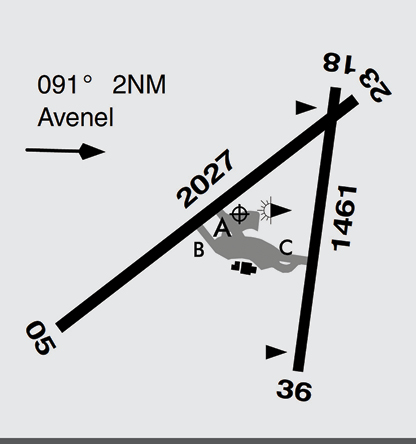
Mangalore is a certified aerodrome located approximately 48 nm north of Melbourne and requires VHF radio carriage and use when operating in the vicinity. Mangalore aerodrome is predominantly used for flight training and recreational flying. Instrument flight training is also conducted. Extensive fixed-wing flight training is conducted at the aerodrome and in an area bound by Seymour, Nagambie, Stanhope and Euroa townships, from SFC to 8,500 ft. When operating in the vicinity, it is recommended landing lights, anti-collision strobes and navigation lights be used. Occasional helicopter operations will also be encountered. It is the pilot-in-command’s responsibility to check current charts, ERSA and NOTAMs for flights in this area.
The Kilmore Gap is a busy VFR thoroughfare between Melbourne and Mangalore. The gap can only be navigated in VMC. If there is a moist airflow from the south, it is possible for low cloud to form on the southern approaches. This may restrict VFR operations through the gap. When entering the VFR inland route from the north, it is important to identify the key navigational feature of Mt Piper, immediately west of the township of Broadford and to the north-east of Kilmore township. If this landmark is not visible due to mist or cloud, consider alternates or returning to Mangalore until weather improves.
Bureau of Meteorology provides a weather camera service at Kilmore Gap to provide pilots with better situational awareness.
Enlarge image