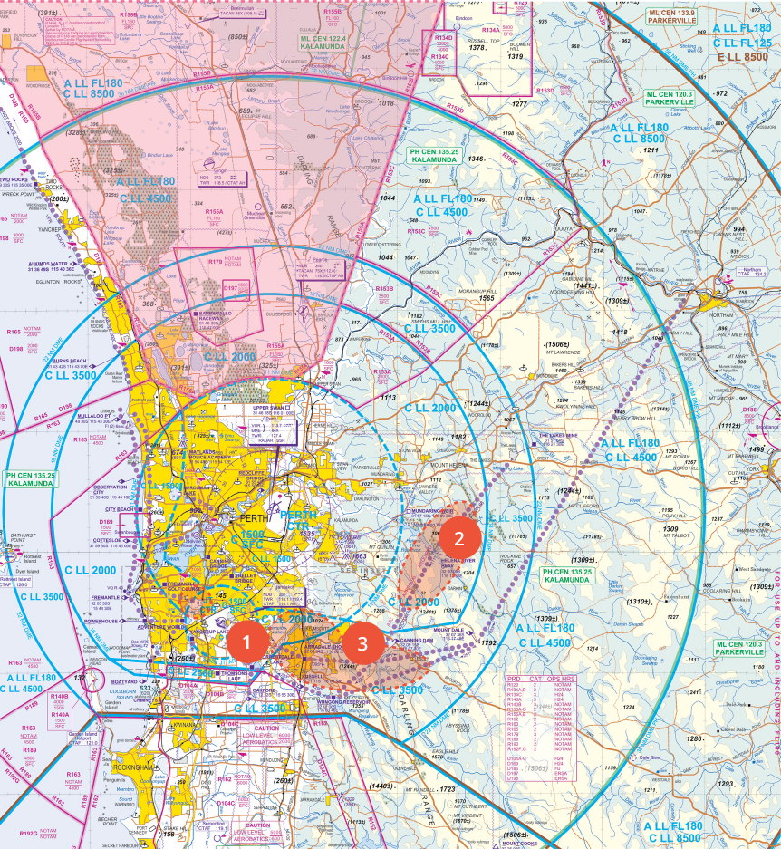
Report at Oakford or Russell for abbreviated clearance. Report at Forrestdale Lake. You may receive circuit joining instructions if not inferred in abbreviated clearance. Have an alternative plan and a suitable decision point if you do not receive clearance, or are unable to call prior to entering controlled airspace.
-
Airspace infringement hotspot: Inbound via Forrestdale Lake
-
Airspace infringement hotspot: Helena River Reservoir area
Use visual or distance checks to remain clear of CTA. Make sure you are tracking clear of or under the 2,000 ft step to the north. When tracking to the north above 2,000 ft OCTA, overfly Mt Dale before turning.
Step distances are from Perth, not Jandakot, therefore be cautious when using GPS.
-
Airspace infringement hotspot: East of Jandakot in the Armadale Shops – Canning Dam – Mt Dale area
Tracking outbound from Jandakot to the east via Armadale Shops, do not climb above 2,000 ft until at or past Armadale Shops. Be cautious of the overlying CTA steps and be sure to track south of the Brookton highway to the Armadale Shops (SHOP) position, which is at the intersection of the Albany and southwest highways.

-
Aircraft
-
Aircraft registration
- Change, transfer or cancel aircraft registration
- Data files for registered aircraft
- Ferry flight registrations
- Find a registered aircraft
- Guidance for deceased estates
- Irrevocable deregistration and export request authorisation (IDERA)
- Register your aircraft
- Registered aircraft operators
- Registration marks
- Request a copy of your registration certificate
- Airworthiness
- Certification
- Design and manufacturing
- Sport aviation
-
Aircraft registration
- Drones
-
Licences and certificates
- Pilots
- Radio operators
- Air traffic controllers
-
Air operators
- Aerial application air operator's certificate
- Aerial work certificate (Part 138)
- Air transport air operator's certificate
- Alternative pathways for specialised endorsements
- Balloon air operator's certificate
- Flight training operators
- Foreign operators
- Guidance for Part 91 approvals
- Replace air operator's certificate
- Aerial photography from aircraft
- Delegates
-
Maintenance engineers
- About aircraft maintenance engineers
- Aircraft maintenance engineer exams
- Aircraft maintenance engineer licence (Part 66)
- Apply for a Part 66 licence
- Become a licensed aircraft maintenance engineer
- Maintenance of composite structures
- Part 66 and working for a Part 145 organisation
- Part 66 self-study training and examination pathway
- Recognition of prior learning
- Removing exclusions
- Licence currency and requalification
- Modular licensing for aircraft maintenance engineers
- Part 66 modular aircraft maintenance engineer licence pathways
- Flight examiners
- Flight instructors
- Aviation medicals
- Medical professionals
- Aviation reference numbers
- English language standards
-
Operations, safety & travel
- Aerodromes
- Airspace
- Aviation safety for pilots
- Safety Management Systems
-
Safety advice
- Cabin safety
- Carriage or discharge of firearms on aircraft
- Community service flights
- Cost sharing flights
- Dangerous goods and air freight
- Displays and events
- Drug and alcohol management
- Electronic flight bag
- Fatigue management
- Hazard identification and management
- Human factors and safety behaviours
- Mercy fights and operating in an emergency
- 5G and aviation safety
- Consumer and passenger advice
- Aeronautical information management
- Training and checking systems
-
Rules
- Regulatory framework
- Rules by category
- Rules by status
- Rules by type
- Changing the rules
-
Compliance and enforcement
- Delegated authority in support of aviation safety investigations
- Enforcement action
- How to comply with the rules
- Recent enforcement actions
- Safety information policy statement
- Sharing safety information
- Strict liability
- Surveillance
- Submitting significant and non-significant changes
- Voluntary suspensions
- Recent enforcement actions
- Reporting unsafe behaviour
- Resources & education
-
About us
- Who we are
- Who we work with
- News and media
-
Reporting and accountability
- Environmental management and performance
- Freedom of information
- Gift and benefits register
- Gender pay gap employer statement
- List of CASA files
- Portfolio budget statements
- Register of privacy impact assessments
- Regulator Performance Framework
- Senate order on agency contracts
- Service standards
- Statement of commitment to child safety
- Work health and safety policy statement
- Protecting the environment
- External security vulnerability disclosure program
- Careers
- Sponsorship and scholarship
- About this website
- Contact us
- Events
- Subscribe

